|
DETERMINING LOCATION OF LAND
The exact location of a land purchase may be found by
using the legal description given in the database entry.
The rectangular coordinate system of surveys divides Illinois into
36-square mile townships that are located in ranges west of the 2nd
Principal Meridian or east or west of the 3rd or the 4th Principal
Meridian. Townships are further located as north or south of base
lines that serve as reference points for each meridian.
Refer to the legal description from the database entry to find the
meridian for the land purchase. Then use the numbers along the
appropriate meridian and base line to count north or south of the
base line and east or west of the principal meridian to locate the
township in which the land is situated. For example, if the legal
description is Township 28N, Range 6E 3rd P.M., begin at the
intersection of the 3rd Principal Meridian and the Centralia Base
Line and count 28 townships north and 6 ranges east to find a
township in the middle of Livingston County.
This township will be divided into 36 sections of 640 acres. Each
section is further subdivided into quarter sections, half-quarter
sections, or quarter-quarter sections. Examples of these
subdivisions within a township appear below. Use the figures below
to determine location within a township and within a section.
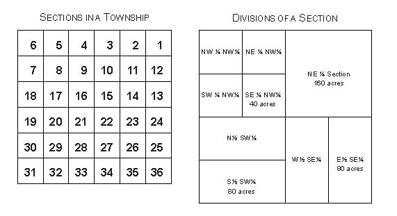
NW - The northwest ¼ of a section (160 acres)
S2NW - South ½ of the northwest ¼ of a section (80 acres)
NENW - The northeast ¼ of the northwest ¼ of a section (40 acres)
FOR MORE INFORMATION,
CLICK HERE
|
