|
Welcome to Columbia
County, New York
I will be adding things as I find the time,
~Sharon Wick~
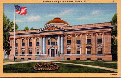
Columbia County Court House, Hudson, NY
A Little History:
At the arrival of European colonists the area was
occupied by the indigenous Mohican Indians. To the
west of the river were the Mohawk and other four tribes
of the Iroquois Confederacy, extending past what is now
the border of New York state. The first known
European exploration of Columbia County was in 1609,
when Henry Hudson, an English explorer sailing for the
Dutch, ventured up the Hudson River. An accident
to his craft forced him to stop at what is now known as
Columbia County, and search for food and supplies. In
1612, the Dutch established trading posts and minor
settlements, constructing New Amsterdam (today's New
York City) and Fort Orange (Albany). Fort Orange
became a center of the fur trade with the Mohawk people.
Traders began to stop at midway points along the Hudson
River, on their travels between New Amsterdam and Fort
Orange. Small settlements arose along the river to
supply the traders' ships.
In 1649, Dutch colonists purchased land
near Claverack and again in 1667. As more Dutch
arrived, the region slowly developed. In 1664, the
English took over New Netherland and renamed it
the Province of New York; they also renamed Fort Orange
as Albany.
In the late 17th century, Robert Livingston, a Scots
immigrant by way of Rotterdam, built on his connections
as Indian agent in the colony and purchased two large
portions of land from the Native Americans. He
gained much larger grants from the provincial
government, for a total of 160,240 acres. He was
made lord of Livingston Manor by the Crown, with all its
perquisites, and started to develop the property
with tenant farmers. In 1710, he sold 6,000 acres of his
property to Queen Anne of Great Britain for use as work
camps and resettlement of Palatine German refugees.
The Crown had supported their passage to New York, and
they were to pay off the costs as indentured labor.
Some 1200 Palatine Germans were brought to Livingston
Manor (now known as Germantown). New York's Governor
Hunter had also helped with these arrangements: the
workers were to manufacture naval stores (e.g., pitch,
resin, and turpentine) from the pine trees in
the Catskill Mountains.
They were promised land for resettlement after
completing their terms of indenture. They were refugees
from years of religious fighting along the border
with France, as well as crop failures from a severe
winter. Work camps were established on both sides of the
Hudson River. The Germans quickly established
Protestant churches at the heart of their community,
which recorded their weddings, births and deaths, among
the first vital records kept in the colony.
After many years, some of the colonists were granted
land in the frontier of the central Mohawk Valley west
of present-day Little Falls in the 100 lots of the
Burnetsfield Patent; in the Schoharie Valley, and other
areas, such as Palatine Bridge along the Mohawk River
west of Schenectady. They were buffer communities
between the British settlements and the Iroquois and
French (the latter located mostly in Canada.)
Columbia County was
formed in 1786 after the American Revolutionary War from
portions of Albany County, once a vast area until
new communities were developed and jurisdictions were
organized. In 1799, the southern boundary of
Columbia County was moved southward to include
that portion of Livingston Manor located in Dutchess
County.
In the nineteenth century, the Vermont Central
Railway was constructed to the area. It provided
transportation north towards Rutland and Burlington,
Vermont, and south towards the major junction town
of Chatham, New York, for travel to points west, south
and east.
|
City: |
|
* Hudson (county seat) |
|
Towns: |
*
Ancram
* Austerlitz
* Canaan
* Chatham
* Claverack
* Clermont
* Copake
* Gallatin
* Germantown |
*
Ghent
* Greenport
* Hillsdale
* Kinderhook
* Livington
* New Lebanon
* Stockport
* Styvesant
* Taghkanic |
|
Villages: |
*
Chatham
* Kinderhook |
*
Philmont
* Valatie |
|
Census-designated places: |
*
Claverack-Red Mills
* Copake
* Copake Falls
* Copake Lake
* Germantown |
*
Ghent
* Lorenz Park
* Neverville
* Slottville
* Taconic Shore |
|
Hamlets: |
*
Boston Corner
* Chatham Center
* Columbiaville
* Craryville
* East Chatham
* Elizaville
* Humphreysville
* Lebanon Springs
* Malden Bridge
* Mellenville
* New Britain |
*
New Lebanon
* New Lebanon Center
* Niverville
* North Chatham
* Old Chatham
* Spencertown
* Stuyvesant Falls
* Red Rock
* West Copake
* West Lebanon |
| |
|
|
Founded: Apr. 4,
1786
Named for: Christopher Columbus
Seat: Hudson
Area: 648 sq. mi.
Time Zone: Eastern Time
SEAL
FLAG
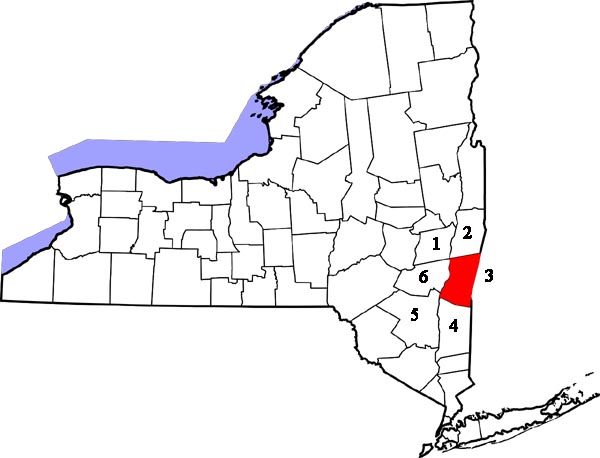
COUNTY MAP
IN PROCESS
Adjacent Counties:
1. Albany County -
Northwest
2. Rensselaer County - North
3. Berkshire County, Massachusetts - East
4. Dutchess County - South
5. Ulster County - Southwest
6. Greene County - West
|
STATE MAP:
 |
|
