|
Welcome to Erie County, New York
I will be adding things as I find the time.
~ Sharon Wick ~

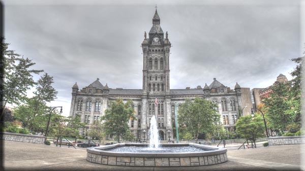
Old County and City Hall
near Buffalo Harbor, NY
A Little History:
When counties were established by the English colonial
authorities in the Province of New York in 1683,
present-day Erie County was inhabited by the Iroquois.
Significant colonization by White Americans did not
begin until after the United States had gained
independence with the end of the American
Revolutionary War in
1783. The U.S. forced the Iroquois to cede most of their
lands, as many had been allies of the British during
the conflict.
About 1800, the Holland Land Company,
formed by American businessmen and their Dutch
associates, extinguished aboriginal claims by purchasing
the land from New York, acquired the title to the
territory of what are today the eight westernmost
counties of New York, surveyed their holdings,
established towns and began selling lots to individuals.
The state was eager to attract settlers and have
homesteads and businesses developed. At this time, all
of western New York was included in Ontario
County.
As the population increased, the state legislature
created Genesee County in
1802 out of part of Ontario County. In 1808, Niagara
County was created out of Genesee County. In 1821, Erie
County was created out of Niagara County, encompassing
all the land between Tonawanda Creek and Cattaraugus
Creek.
The first towns formed in present-day Erie County were
the Town of Clarence and
the Town of Willink.
Clarence and Willink comprised the northern and southern
portions of Erie county, respectively. Clarence is still
a distinct town, but Willink was quickly subdivided into
other towns. When Erie County was established in 1821,
it consisted of the towns of Amherst, Aurora, Boston,
Clarence, Collins, Concord, Eden, Evans, Hamburg,
Holland, Sardinia and Wales.
In 1861, the hamlet of Town Line in
the Town of Lancaster voted
85–40 to secede from the Union.
Town Line never sought admission into the Confederate
States of America and
there is no evidence that men from the community ever
fought for the Confederacy. Some reporting from that
time indicates the vote was a joke. On January 24, 1946,
as part of a nationally reported event, Town Line voted
to officially return to the Union after 85 years of
Union secession.
Source: Wikipedia.org
|
Towns: |
*
Alden
* Amherst
* Aurora
* Boston
* Brant
* Cheektowaga
* Clarence
* Colden
* Collins
* Concord
* Eden
* Elma
* Evans |
*
Grand Island
* Hamburg
* Holland
* Lancaster
* Marlla
* Newstead
* North Collins
* Orchard Park
* Sardinia
* Tonawanda
* Wales
* West Seneca |
|
Hamlets: |
* Akron Junction
* Alden Center
* Armor
* Alhol Springs
* Bagdad
* Bellevue
* Big Tree
* Blakeley
* Blossom
* Boston
* Bowmansville
* Brant
* Brighton
* Carnegie
* Chaffee
* Clarksburg
* Cleveland Hill
* Clifton Heights
* Collins Center
* Concord
* Creekside
* Crittenden
* Dellwood
* Derby
* Doyle
* Duells Corner
* Dutchtown
* East Amherst
* East Concord
* East Eden
* East Elma
* East Seneca
* Ebenezer
* Eden Valley
* Elliott
* Elma
* Evans Center
* Ferry Village
* Footes
* Forks
* Fowlerville
* Gardenville
* Getzville
* Glenwood
* Green acres
* Griffins Mills
* Holland
* Hunts Corners
* Jerusalem Corners
* Jewettville
* Kenilworth
* lake View
* Langford |
*
Lawtons
* Locksley Park
* Looneyville
* Loveland
* Marilla
* Marshfield
* Millersport
* Millgrove
* Morton Corners
* Mount Vernon
* Murrays Corner
* New Ebenezer
* New Oregon
* North Bailey
* North Evans
* Oakfield
* Patchin
* Peters Corners
* Pine Hill
* Pinehurst
* Pontiac
* Porterville
* Protection
* Sand Hill
* Sandy Beach
* Scranton
* Sheenwater
* Shirley
* Snyder
* South Cheektowaga
* South Newstead
* South Wales
* Spring Brook
* Swifts Mills
* Taylor Hollow
* Town Line Station
* Swormville
* Walden Cliffs
* Wales Hollow
* Water Valley
* Webster Corners
* Wende
* West Alden
* West Falls
* Weyer
* Williston
* Windom
* Wolcottsburg
* Woodlawn
* Woodside
* Wyandale
* Zoar |
|
Indian
Reservations: |
*
Cattaraugus Reservation
* Tonawanda Reservation |
|

Named for: Eriechronon
Seat: Buffalo
Area: 1,227 sq. mi.
Time Zone: Eastern Time
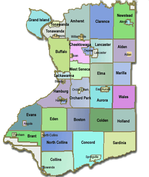
COUNTY MAP

Adjacent Counties:
1. Niagara County - North
2. Genesee County - Northeast
3. Wyoming County - Southeast
4. Cattaraugus County - South
5. Chautauqua County - Southwest
6. Niagara Region, Ontario Canada -
Northwest |
STATE MAP:
|
GENEALOGY
EXPRESS
FREE GENEALOGY RESEARCH is MY MISSION
This Webpage has been
created by Sharon Wick exclusively for Genealogy Express ©2008
Submitters retain all copyrights
|